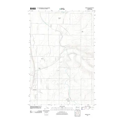
2011 Map of Wheeler
USGS Topo · Published 2011About this map
The settlement of Wheeler and the residential area of Mitchell anchor this landscape in Grant County, where the agricultural infrastructure of the Columbia Basin Project is clearly visible. The East Low Canal carves a path through the eastern portion of the map, supported by engineering works like the Sand Coulee Siphon. This network reflects the transition of the arid high desert into a managed agricultural zone. To the southwest, the Moses Lake Municipal Airport stands as a primary landmark, while the natural topography is defined by the deep, winding paths of Black Rock Coulee, Rocky Coulee, and Sand Coulee. The northern reaches of the quadrangle include Artesian Lake, surrounded by a rigid grid of local roads including 11 NE Rd and Road 10 NE that delineate modern property boundaries across the sagebrush steppe.
Find a feature on this map
49 named features on this map. Tap any name to fly to it.
Don’t see what you’re looking for? This feature index may not catch every label — zoom into the map to look around manually.
Map Details
Editions of this 2011 Wheeler Map
This is the sole edition of this map. No revisions or reprints were ever made.
Other maps of this area

1912 · Moses Lake
USGS Topo · 1:62,500

1923 · Wheeler
USGS Topo · 1:62,500

1925 · Wheeler
USGS Topo · 1:62,500

1953 · Ritzville
USGS Topo · 1:250,000

1956 · Wheeler
USGS Topo · 1:24,000

1956 · Moses Lake South
USGS Topo · 1:24,000

1956 · Moses Lake North
USGS Topo · 1:24,000

1956 · Gloyd
USGS Topo · 1:24,000

1956 · Wilson Creek SW
USGS Topo · 1:24,000
1956 · Bassett Junction
USGS Topo · 1:24,000