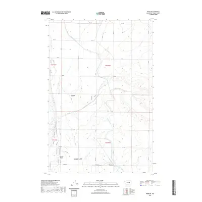
2020 Map of Wheeler
USGS Topo · Published 2020About this map
East Low Canal and Rocky Coulee Wasteway dominate the agricultural landscape of this Grant County region, illustrating the complex irrigation infrastructure that transformed this part of the Columbia Basin. The map details the intersection of rural residential pockets and industrial transport, specifically around the settlement of Wheeler and the residential area of Mitchell. To the southwest, the expansion of Moses Lake is evident, centered on the Moses Lake Municipal Airport and its supporting infrastructure like Municipal Hangar Rd. The terrain is defined by a rigorous grid of section roads, including Rd 11 NE and Rd 3 NE, which navigate the subtle draws and coulees. This survey provides a precise look at the modern footprint of the area's aviation and water-management systems.
Find a feature on this map
40 named features on this map. Tap any name to fly to it.
Don’t see what you’re looking for? This feature index may not catch every label — zoom into the map to look around manually.
Map Details
Editions of this 2020 Wheeler Map
This is the sole edition of this map. No revisions or reprints were ever made.
Other maps of this area

1912 · Moses Lake
USGS Topo · 1:62,500

1923 · Wheeler
USGS Topo · 1:62,500

1925 · Wheeler
USGS Topo · 1:62,500

1953 · Ritzville
USGS Topo · 1:250,000

1956 · Wheeler
USGS Topo · 1:24,000

1956 · Moses Lake South
USGS Topo · 1:24,000

1956 · Moses Lake North
USGS Topo · 1:24,000

1956 · Gloyd
USGS Topo · 1:24,000

1956 · Wilson Creek SW
USGS Topo · 1:24,000
1956 · Bassett Junction
USGS Topo · 1:24,000