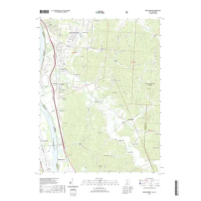
2019 Map of Wheelersburg
USGS Topo · Published 2019About this map
Wheelersburg and its surrounding communities along the Ohio River reflect the deep-rooted settlement patterns of Scioto County. The landscape is defined by the winding course of Pine Creek and a dense network of hollows, including Riepenhoff Hollow and Germany Hollow, which carve through the rising terrain toward the Wayne National Forest. For genealogists, the map is an exceptionally rich resource, documenting numerous family and community burial grounds such as the Old Wheelersburg Cem, Memorial Burial Park, and the Old Dutch Cem. The concentration of settlements like Allentown, Sand Hill, and Garden City along Gallia Pike illustrates the historical corridor of development between the riverbank and the interior ridges. Moving south, the map details the transition into Highland Park and Powellsville, where the Powellsville Baptist Cem marks the local social and spiritual center for rural residents.
Find a feature on this map
79 named features on this map. Tap any name to fly to it.
Don’t see what you’re looking for? This feature index may not catch every label — zoom into the map to look around manually.
Map Details
Editions of this 2019 Wheelersburg Map
This is the sole edition of this map. No revisions or reprints were ever made.
Other maps of this area

1898 · Ironton
USGS Topo · 1:62,500

1900 · Ironton
USGS Topo · 1:62,500

1911 · Sciotoville
USGS Topo · 1:62,500

1912 · Oak Hill
USGS Topo · 1:62,500

1913 · Sciotoville
USGS Topo · 1:62,500

1926 · Greenup
USGS Topo · 1:48,000

1930 · Greenup
USGS Topo · 1:62,500
1953 · Load
USGS Topo · 1:24,000

1953 · Greenup
USGS Topo · 1:24,000
1953 · Portsmouth
USGS Topo · 1:24,000