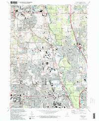
1993 Map of Wheeling
USGS Topo · Published 1993About this map
The Des Plaines River corridor serves as the spine of this northern Illinois suburban landscape, where the Lake County Forest Preserve and Potawatomi Woods create a substantial green buffer between rapidly expanding residential developments. The map reveals the sophisticated mid-century commercial and educational infrastructure of the region, anchored by the Hawthorn Center (Mall) and institutions like Lake Forest Academy. Suburban growth is evidenced by an extensive network of schools including Wheeling High Sch and Adlai E Stevenson Sch, alongside the legacy of local agriculture indicated by scattered Gravel Pits.
Find a feature on this map
91 named features on this map. Tap any name to fly to it.
Don’t see what you’re looking for? This feature index may not catch every label — zoom into the map to look around manually.
Map Details
Editions of this 1993 Wheeling Map
2 editions found
Other maps of this area

1900 · Highwood
USGS Topo · 1:62,500

1906 · Waukegan
USGS Topo · 1:62,500

1908 · Waukegan
USGS Topo · 1:62,500

1920 · Grays Lake
USGS Topo · 1:62,500

1923 · Grays Lake
USGS Topo · 1:62,500

1923 · Barrington
USGS Topo · 1:62,500

1927 · Arlington Heights
USGS Topo · 1:24,000

1928 · Wheeling
USGS Topo · 1:24,000

1928 · Highland Park
USGS Topo · 1:24,000

1929 · Park Ridge
USGS Topo · 1:24,000