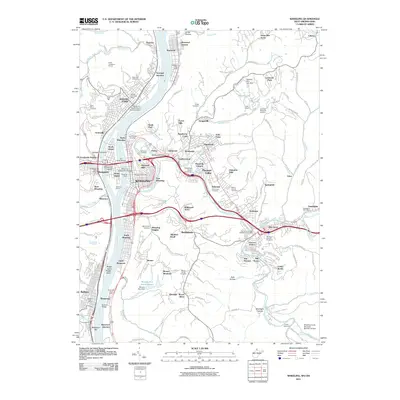
2011 Map of Wheeling
USGS Topo · Published 2011About this map
Wheeling and the industrial banks of the Ohio River appear in this 2011 survey, showing the complex interplay of river commerce and urban expansion. The central river geography is defined by Wheeling Island, connected by the historic Wheeling Suspension Bridge and Fort Henry Bridge to the bustling mainland wharf and downtown district. The map captures a sophisticated network of early 21st-century infrastructure, including the Wheeling and Lake Erie RR and a dense array of neighborhoods from North Wheeling to Elm Grove. To the east, the landscape transitions from the urban core toward the educational grounds of Wheeling Jesuit University and Mount de Chantal. Local heritage is deeply etched into the hillsides, marked by numerous burial grounds like Mount Wood Cemetery and Riverview Cemetery, alongside industrial features like the Ayers Limestone Quarry and the specialized Warwood-Martins Ferry Seaplane Base.
Find a feature on this map
165 named features on this map. Tap any name to fly to it.
Don’t see what you’re looking for? This feature index may not catch every label — zoom into the map to look around manually.
Map Details
Editions of this 2011 Wheeling Map
This is the sole edition of this map. No revisions or reprints were ever made.
Other maps of this area

1902 · Wheeling
USGS Topo · 1:62,500

1904 · Cameron
USGS Topo · 1:62,500

1905 · Clarington
USGS Topo · 1:62,500

1905 · St. Clairsville
USGS Topo · 1:62,500

1935 · Cameron
USGS Topo · 1:62,500

1935 · Clarington
USGS Topo · 1:62,500

1935 · Wheeling
USGS Topo · 1:62,500

1940 · Clarington
USGS Topo · 1:62,500

1942 · Cameron
USGS Topo · 1:62,500

1942 · Wheeling
USGS Topo · 1:62,500