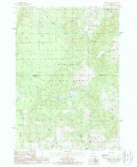
1987 Map of Whipple Lake
USGS Topo · Published 1987About this map
The Manistee National Forest defines the wooded landscape of this region during the 1980s, where the winding Middle Branch Pere Marquette River flows through the northern townships of Yates and Chase. The map documents a sparsely populated area characterized by significant water resources and small-scale resource extraction, including several Gravel Pits and a Sand Pit. Local hydrology is prominent, with numerous kettle lakes and wetlands such as Whipple Lake, Chard Lake, and Toman Lake dotting the glaciated terrain. The intersection of the Lake and Newaygo County line runs horizontally across the center of the sheet, providing a precise record of late-20th-century property and administrative boundaries in this part of Michigan. A small Cem and family-named waterways like Pease Creek and McDuffee Creek offer specific touchpoints for local genealogical research.
Find a feature on this map
20 named features on this map. Tap any name to fly to it.
Don’t see what you’re looking for? This feature index may not catch every label — zoom into the map to look around manually.
Map Details
Editions of this 1987 Whipple Lake Map
This is the sole edition of this map. No revisions or reprints were ever made.
Other maps of this area

1931 · Chase NE
USGS Topo · 1:31,680

1931 · Baldwin NE
USGS Topo · 1:31,680

1932 · Chase NW
USGS Topo · 1:31,680

1954 · Midland
USGS Topo · 1:250,000

1958 · Midland
USGS Topo · 1:250,000

1958 · Woodville
USGS Topo · 1:62,500

1959 · Midland
USGS Topo · 1:250,000

1959 · Reed City
USGS Topo · 1:62,500

1959 · Baldwin
USGS Topo · 1:62,500

1959 · White Cloud
USGS Topo · 1:62,500