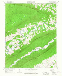
1965 Map of White Gate
USGS Topo · Published 1967About this map
Walker Mountain and its neighbors define a landscape of rhythmic ridges and deep valleys in this mid-1960s survey of the Virginia highlands. The winding course of Walker Creek serves as the primary axis for settlement and agriculture, passing by the community of White Gate and the Walkers Creek Ch. To the north, the Jefferson National Forest covers high ground like Sugar Run Mountain, where the Appalachian Trail traverses the crest near the Wapiti Shelter and Honey Spring Patrol Cabin. Evidence of institutional land use is visible at the Bland State Correctional Farm, which straddles the county line. The map highlights a series of distinctive landforms like Flat Hollow and the intriguing Silver Mine Hollow, alongside local landmarks such as the Sugar Run Radio Facility and the Sassin Ch at Alum Springs.
Find a feature on this map
39 named features on this map. Tap any name to fly to it.
Don’t see what you’re looking for? This feature index may not catch every label — zoom into the map to look around manually.
Map Details
Editions of this 1965 White Gate Map
2 editions found
Other maps of this area

1890 · Dublin
USGS Topo · 1:125,000

1891 · Dublin
USGS Topo · 1:125,000

1913 · Peterstown
USGS Topo · 1:48,000

1916 · Peterstown
USGS Topo · 1:62,500

1923 · Pearisburg
USGS Topo · 1:62,500

1925 · Peterstown
USGS Topo · 1:62,500

1932 · Peterstown
USGS Topo · 1:48,000

1932 · Pearisburg
USGS Topo · 1:48,000

1934 · Pulaski
USGS Topo · 1:48,000

1937 · Pearisburg
USGS Topo · 1:62,500