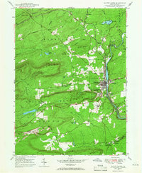
1947 Map of White Haven
USGS Topo · Published 1966About this map
The Lehigh River serves as the central artery for this mid-century portrait of industrial and rural Pennsylvania, carving a deep valley through Nescopeck Mountain and Green Mountain. At its banks, White Haven emerges as a primary hub of activity, surrounded by satellite communities like Middleburg, East Side, and Tannery. The landscape reveals a complex network of transportation and industry, with the Central RR of Pennsylvania and the Lehigh Valley RR tracing the river's winding course.
Find a feature on this map
47 named features on this map. Tap any name to fly to it.
Don’t see what you’re looking for? This feature index may not catch every label — zoom into the map to look around manually.
Map Details
Editions of this 1947 White Haven Map
4 editions found
Other maps of this area

1889 · Hazleton
USGS Topo · 1:62,500

1891 · Wilkesbarre
USGS Topo · 1:62,500

1891 · Hazleton
USGS Topo · 1:62,500

1893 · Hazleton
USGS Topo · 1:62,500

1894 · Wilkesbarre
USGS Topo · 1:62,500

1922 · Mauch Chunk
USGS Topo · 1:62,500

1922 · Stoddartsville
USGS Topo · 1:62,500

1924 · Stoddartsville
USGS Topo · 1:62,500

1924 · Mauch Chunk
USGS Topo · 1:62,500

1943 · Scranton
USGS Topo · 1:125,000