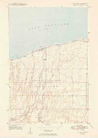
1949 Map of White Pine
USGS Topo · Published 1949About this map
Lake Superior defines the northern edge of this Upper Peninsula survey, where the rugged shoreline of Union Bay meets the copper-bearing landscape of Ontonagon County. The interior is characterized by the convergence of the Ottawa National Forest and the eastern portion of Porcupine Mountain State Park. The settlement of White Pine sits as a central node in a network of logging and mining interests, evidenced by nearby Sterling Camp, Greenwood Camp, and the uniquely named None Such to the southwest. Several waterways, including the Union River, Little Iron River, and Mineral River, flow northward through steep-contoured terrain toward the lake. Along the coast, Silver City marks the junction of state routes near Gull Point, serving as a gateway to the dense forests and mineral resources that drove the local economy in the late 1940s.
Find a feature on this map
25 named features on this map. Tap any name to fly to it.
Don’t see what you’re looking for? This feature index may not catch every label — zoom into the map to look around manually.
Map Details
Editions of this 1949 White Pine Map
2 editions found
Other maps of this area

1949 · Matchwood NW
USGS Topo · 1:24,000

1949 · White Pine
USGS Topo · 1:24,000

1949 · Bergland NE
USGS Topo · 1:24,000

1955 · Ontonagon
USGS Topo · 1:62,500

1956 · Bergland NE
USGS Topo · 1:24,000

1956 · Bergland
USGS Topo · 1:62,500

1956 · White Pine
USGS Topo · 1:24,000

1956 · Matchwood NW
USGS Topo · 1:24,000

1956 · White Pine
USGS Topo · 1:62,500

1956 · Matchwood
USGS Topo · 1:62,500