
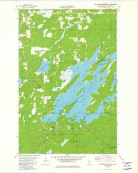
1981 Map of Whiteface Reservoir
USGS Topo · Published 1985About this map
Whiteface Reservoir dominates this landscape in central St. Louis County, where the sprawling waterway and its many islands are bordered by the Superior National Forest. To the south, the terrain transitions into the Cloquet Valley State Forest, defined by the winding course of the Cloquet River and its confluence with the South Branch Whiteface River. The map reveals the local infrastructure of the early 1980s, including the Cloquet Valley Lookout Tower and a Community Hall located west of the reservoir. Evidence of former industrial activity remains visible through an Old Railroad Grade cutting through the northern timberland, while smaller water bodies like Markham Lake and Linwood Lake dot the surrounding forest. Genealogists and local historians will find the Markham Cem positioned near the banks of the Paleface River, providing a specific point of reference for the families of the Colvin area.
Find a feature on this map
28 named features on this map. Tap any name to fly to it.
Don’t see what you’re looking for? This feature index may not catch every label — zoom into the map to look around manually.
Map Details
Editions of this 1981 Whiteface Reservoir Map
2 editions found
Other maps of this area

1951 · Palo
USGS Topo · 1:24,000

1951 · Makinen
USGS Topo · 1:24,000

1954 · Hibbing
USGS Topo · 1:250,000

1956 · Whiteface
USGS Topo · 1:24,000

1957 · Hibbing
USGS Topo · 1:250,000

1957 · Markham
USGS Topo · 1:62,500

1957 · Comstock Lake
USGS Topo · 1:24,000
1957 · Boulder Lake Reservoir NE
USGS Topo · 1:24,000

1958 · Hibbing
USGS Topo · 1:250,000

1964 · Hibbing
USGS Topo · 1:250,000