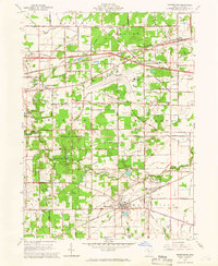
1964 Map of Whitehouse
USGS Topo · Published 1966About this map
Oak Openings Park and the adjacent Maumee State Forest dominate the western landscape of this Lucas County region, preserving a unique sandy ecosystem even as mid-century infrastructure expanded around it. The map documents the heavy presence of the Toledo Express Airport and the path of the Ohio Turnpike cutting through the northern townships of Spencer and Springfield. In the south, the village of Whitehouse serves as a local hub near the Anthony Wayne Trail, while smaller settlements like Monclova, Crissey, and East Swanton dot the rail corridors of the New York Central and Wabash RR. Genealogists will find interest in localized landmarks such as the Antioch Ch, Roth Cem, and the various cemeteries and schools like Anthony Wayne High Sch that served these growing rural communities.
Find a feature on this map
38 named features on this map. Tap any name to fly to it.
Don’t see what you’re looking for? This feature index may not catch every label — zoom into the map to look around manually.
Map Details
Editions of this 1964 Whitehouse Map
2 editions found
Other maps of this area

1900 · Toledo
USGS Topo · 1:62,500

1901 · Bowling Green
USGS Topo · 1:62,500

1903 · Bowling Green
USGS Topo · 1:62,500

1909 · Mc Clure
USGS Topo · 1:62,500

1911 · Swanton
USGS Topo · 1:62,500

1914 · Swanton
USGS Topo · 1:62,500

1935 · Grand Rapids
USGS Topo · 1:24,000

1935 · Whitehouse
USGS Topo · 1:24,000

1935 · Maumee
USGS Topo · 1:24,000

1935 · Berkey
USGS Topo · 1:24,000