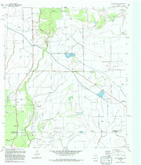
1994 Map of Whites Bayou
USGS Topo · Published 1994About this map
Whites Bayou meanders through this portion of Liberty County, defining a landscape shaped by both natural drainage and an extensive network of irrigation canals. The settlement of Devers sits at the northern edge of this coastal plain, where the flat terrain is divided between wooded areas and open fields. A sophisticated system of water management is evident throughout the survey, with numerous unnamed canals and lateral ditches engineered to support the local agricultural economy. This 1994 edition, based on earlier aerial photography and field checks, provides a precise look at the rural infrastructure of East Texas during the late twentieth century, showing the intersection of natural bayous with human-made water diversions and petroleum-related structures.
Find a feature on this map
2 named features on this map. Tap any name to fly to it.
Don’t see what you’re looking for? This feature index may not catch every label — zoom into the map to look around manually.
Map Details
Editions of this 1994 Whites Bayou Map
This is the sole edition of this map. No revisions or reprints were ever made.
Other maps of this area

1942 · Anahuac
USGS Topo · 1:24,000

1943 · Whites Bayou
USGS Topo · 1:24,000

1943 · Liberty
USGS Topo · 1:125,000

1943 · Stowell
USGS Topo · 1:24,000

1945 · Nolte
USGS Topo · 1:31,680

1950 · Houston
USGS Topo · 1:250,000

1954 · Beaumont
USGS Topo · 1:250,000

1955 · Daisetta
USGS Topo · 1:62,500

1955 · Sour Lake
USGS Topo · 1:62,500

1956 · Houston
USGS Topo · 1:250,000