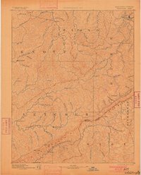
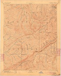
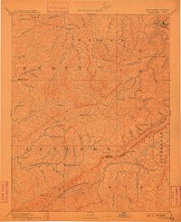
1892 Map of Whitesburg
USGS Topo · Published 1900About this map
Whitesburg and Pikeville anchor this late 19th-century reconnaissance, which covers a heavily dissected landscape where central Appalachian life followed the deep valleys of the North Fork of Kentucky River and the various forks of Beaver Creek. The settlement pattern is strictly riparian, with small communities like Hindman, Lackey, and the curiously named Razor Blade established along watercourses such as Troublesome Creek and Rockhouse Creek.
Find a feature on this map
91 named features on this map. Tap any name to fly to it.
Don’t see what you’re looking for? This feature index may not catch every label — zoom into the map to look around manually.
Map Details
Editions of this 1892 Whitesburg Map
4 editions found

Other maps of this area

1886 · Prestonsburg
USGS Topo · 1:125,000

1886 · Grundy
USGS Topo · 1:125,000

1887 · Jonesville
USGS Topo · 1:125,000

1887 · Warfield
USGS Topo · 1:125,000

1889 · Salyersville
USGS Topo · 1:125,000

1890 · Whitesburg
USGS Topo · 1:125,000

1890 · Grundy
USGS Topo · 1:125,000

1891 · Hazard
USGS Topo · 1:125,000

1891 · Jonesville
USGS Topo · 1:125,000

1891 · Salyersville
USGS Topo · 1:125,000