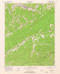
1954 Map of Whitesburg
USGS Topo · Published 1976About this map
Whitesburg serves as the focal point for this mid-century topographic study, situated along the North Fork Kentucky River and the Louisville & Nashville railroad line. The landscape is defined by the heavy ridgelines of Pine Mountain and Black Mountain, which dictate the placement of small valley communities like Dongola, Whitco, and Eolia. This 1954 era survey reveals a high density of rural institutions, including the Big Cowan Ch, Thomas Sch, and Cram Creek Sch, reflecting the community-centric development of Letcher County prior to major highway modernizations. To the south, the terrain rises into the Jefferson National Forest at the Kentucky-Virginia border. Evidence of the local extractive economy is present in the numerous mines and a quarry dotted throughout the hollows, while landmarks such as Bright Tower and the Post Office in Whitesburg anchor the local geography.
Find a feature on this map
65 named features on this map. Tap any name to fly to it.
Don’t see what you’re looking for? This feature index may not catch every label — zoom into the map to look around manually.
Map Details
Editions of this 1954 Whitesburg Map
4 editions found
Other maps of this area

1890 · Whitesburg
USGS Topo · 1:125,000

1892 · Whitesburg
USGS Topo · 1:125,000

1894 · Estillville
USGS Topo · 1:125,000

1912 · Pound
USGS Topo · 1:48,000

1913 · Oven Fork
USGS Topo · 1:48,000

1914 · Pound
USGS Topo · 1:62,500

1915 · Whitesburg
USGS Topo · 1:62,500

1920 · Wise
USGS Topo · 1:48,000

1921 · Big Stone Gap
USGS Topo · 1:48,000

1921 · Wise
USGS Topo · 1:62,500