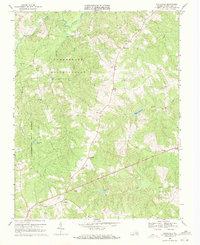
1969 Map of Whiteville
USGS Topo · Published 1971About this map
The northern reaches of the Cumberland State Forest dominate this Virginia landscape, where the Willis River snakes through the Piedmont terrain. This 1960s survey illustrates a region defined by its creeks and millponds, most notably Flippen Millpond and Bonbrook Lake. The small settlements of Whiteville, Ashby, and Oak Forest are clustered along the roadway network, punctuated by community anchors like Thomas Chapel, Mt Calvary Ch, and Bethlehem Ch.
Find a feature on this map
23 named features on this map. Tap any name to fly to it.
Don’t see what you’re looking for? This feature index may not catch every label — zoom into the map to look around manually.
Map Details
Editions of this 1969 Whiteville Map
2 editions found
Other maps of this area

1891 · Palmyra
USGS Topo · 1:125,000

1891 · Farmville
USGS Topo · 1:125,000

1893 · Farmville
USGS Topo · 1:125,000

1895 · Palmyra
USGS Topo · 1:125,000

1897 · Palmyra
USGS Topo · 1:125,000

1947 · Roanoke
USGS Topo · 1:250,000

1950 · Dillwyn
USGS Topo · 1:62,500

1958 · Farmville
USGS Topo · 1:62,500

1958 · Jetersville
USGS Topo · 1:62,500

1958 · Dillwyn
USGS Topo · 1:62,500