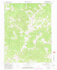
1969 Map of Whiteville
USGS Topo · Published 1981About this map
The Cumberland State Forest dominates the western half of this landscape, where the Willis River and its tributaries, including Bigger Creek and Reynolds Creek, carve through the wooded terrain. This 1969 survey, photorevised in the early 1980s, highlights a rural economy transitioning from agriculture toward forest management and local leisure, evidenced by the presence of a Drive-in Theater and Bonbrook Lake.
Find a feature on this map
22 named features on this map. Tap any name to fly to it.
Don’t see what you’re looking for? This feature index may not catch every label — zoom into the map to look around manually.
Map Details
Editions of this 1969 Whiteville Map
2 editions found
Other maps of this area

1891 · Palmyra
USGS Topo · 1:125,000

1891 · Farmville
USGS Topo · 1:125,000

1893 · Farmville
USGS Topo · 1:125,000

1895 · Palmyra
USGS Topo · 1:125,000

1897 · Palmyra
USGS Topo · 1:125,000

1947 · Roanoke
USGS Topo · 1:250,000

1950 · Dillwyn
USGS Topo · 1:62,500

1958 · Farmville
USGS Topo · 1:62,500

1958 · Jetersville
USGS Topo · 1:62,500

1958 · Dillwyn
USGS Topo · 1:62,500