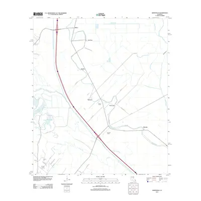
2012 Map of Whiteville
USGS Topo · Published 2012About this map
The Bayou Boeuf-Cocodrie Diversion Channel dominates this 2012 landscape in St. Landry Parish, cutting a massive straight path through the natural meanders of Bayou Boeuf and Bayou Cocodrie. This hydraulic engineering defines the modern era of the region, contrasting with the older settlement patterns found at Whiteville and Saint Louis. Local history is visible in the network of farm roads like Cotton Patch Rd and Cane Brake, which reflect the area's agricultural roots.
Find a feature on this map
42 named features on this map. Tap any name to fly to it.
Don’t see what you’re looking for? This feature index may not catch every label — zoom into the map to look around manually.
Map Details
Editions of this 2012 Whiteville Map
This is the sole edition of this map. No revisions or reprints were ever made.
Other maps of this area

1935 · Turkey Creek
USGS Topo · 1:62,500

1939 · Opelousas
USGS Topo · 1:62,500

1947 · Ville Platte
USGS Topo · 1:31,680

1948 · Bunkie
USGS Topo · 1:62,500

1949 · Turkey Creek
USGS Topo · 1:62,500

1952 · Lake Charles
USGS Topo · 1:250,000

1954 · Lake Charles
USGS Topo · 1:250,000

1956 · Opelousas
USGS Topo · 1:62,500

1957 · Opelousas
USGS Topo · 1:62,500
1960 · Ville Platte
USGS Topo · 1:62,500