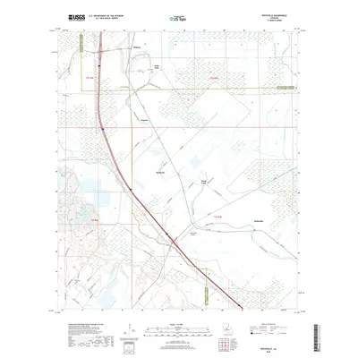
2018 Map of Whiteville
USGS Topo · Published 2018About this map
Bayou Boeuf and Bayou Cocodrie define the agricultural lowlands of the Louisiana prairie near the intersection of three parishes. This 2018 survey documents a landscape where traditional bayou-side settlements like Whiteville and Barbreck remain connected by historical routes such as La 182 and La 29. The map records a dense network of local roads including Cotton Patch Rd and Cane Brake, reflecting a long-standing land-use pattern of large holdings interspersed with small rural communities. For genealogists, the Fontenot Cem provides a specific point of interest in the western portion of the quadrangle. Significant water features like Cazan Lake, Indian Lake, and Coulee Teal are mapped alongside modern infrastructure such as the Whiteville Airport. Small settlements like Gold Dust, Augusta, and Saint Louis further illustrate the dispersed residential and agricultural character of St. Landry and Evangeline Parishes.
Find a feature on this map
56 named features on this map. Tap any name to fly to it.
Don’t see what you’re looking for? This feature index may not catch every label — zoom into the map to look around manually.
Map Details
Editions of this 2018 Whiteville Map
This is the sole edition of this map. No revisions or reprints were ever made.
Other maps of this area

1935 · Turkey Creek
USGS Topo · 1:62,500

1939 · Opelousas
USGS Topo · 1:62,500

1947 · Ville Platte
USGS Topo · 1:31,680

1948 · Bunkie
USGS Topo · 1:62,500

1949 · Turkey Creek
USGS Topo · 1:62,500

1952 · Lake Charles
USGS Topo · 1:250,000

1954 · Lake Charles
USGS Topo · 1:250,000

1956 · Opelousas
USGS Topo · 1:62,500

1957 · Opelousas
USGS Topo · 1:62,500
1960 · Ville Platte
USGS Topo · 1:62,500