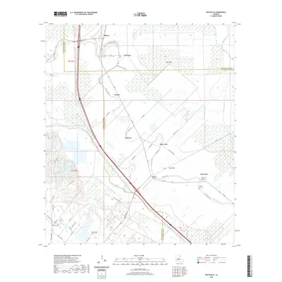
2020 Map of Whiteville
USGS Topo · Published 2020About this map
Bayou Cocodrie and Bayou Boeuf dominate the low-lying geography where the borders of Evangeline, Avoyelles, and St. Landry Parishes converge. This modern landscape is characterized by a network of small agricultural settlements and rural community hubs, including Whiteville, Barbreck, and Augusta. The presence of numerous faith and burial sites, such as the Resurrection Mission Chapel Cem and Mount Pilgrim Baptist Cem, reflects the deep-rooted social history of this Louisiana delta region. Local infrastructure is defined by a mix of historic parish roads and the Whiteville Airport, interspersed among wetland features like Coulee Teal and Cazan Lake. The map details a transition from dense wetland areas toward established farming loops such as Gold Dust Loop, providing a clear view of the parish lines and the intricate waterways that still dictate the area's development and drainage.
Find a feature on this map
56 named features on this map. Tap any name to fly to it.
Don’t see what you’re looking for? This feature index may not catch every label — zoom into the map to look around manually.
Map Details
Editions of this 2020 Whiteville Map
This is the sole edition of this map. No revisions or reprints were ever made.
Other maps of this area

1935 · Turkey Creek
USGS Topo · 1:62,500

1939 · Opelousas
USGS Topo · 1:62,500

1947 · Ville Platte
USGS Topo · 1:31,680

1948 · Bunkie
USGS Topo · 1:62,500

1949 · Turkey Creek
USGS Topo · 1:62,500

1952 · Lake Charles
USGS Topo · 1:250,000

1954 · Lake Charles
USGS Topo · 1:250,000

1956 · Opelousas
USGS Topo · 1:62,500

1957 · Opelousas
USGS Topo · 1:62,500
1960 · Ville Platte
USGS Topo · 1:62,500