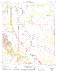
1966 Map of Whiteville
USGS Topo · Published 1992About this map
The low-lying bayou country of the St. Landry, Evangeline, and Avoyelles parish borders is defined here by an intricate network of waterways and early industrial footprints. The Boeuf-Cocodrie Diversion Channel cuts a prominent diagonal across the landscape, managing the flow between Bayou Boeuf and Bayou Cocodrie. Small agricultural and rail-aligned settlements like Whiteville, Gold Dust, and Barbreck are scattered throughout the region, many connected by an Old Railroad Grade that speaks to the area's former transportation network.
Find a feature on this map
34 named features on this map. Tap any name to fly to it.
Don’t see what you’re looking for? This feature index may not catch every label — zoom into the map to look around manually.
Map Details
Editions of this 1966 Whiteville Map
3 editions found
Other maps of this area

1935 · Turkey Creek
USGS Topo · 1:62,500

1939 · Opelousas
USGS Topo · 1:62,500

1947 · Ville Platte
USGS Topo · 1:31,680

1948 · Bunkie
USGS Topo · 1:62,500

1949 · Turkey Creek
USGS Topo · 1:62,500

1952 · Lake Charles
USGS Topo · 1:250,000

1954 · Lake Charles
USGS Topo · 1:250,000

1956 · Opelousas
USGS Topo · 1:62,500

1957 · Opelousas
USGS Topo · 1:62,500
1960 · Ville Platte
USGS Topo · 1:62,500