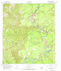
1954 Map of Wiergate SE
USGS Topo · Published 1976About this map
The Sabine River forms the winding border between Texas and Louisiana on this mid-century survey, defining a landscape dominated by complex waterways and wetlands. Low-lying terrain features such as Palmettos Brake, Sibo Brake, and Evans Brake indicate the seasonal flooding patterns of the river valley. In the western uplands of Newton County, a dismantled railroad cuts through the timbered hills near Gunter Hill, signaling a shift in the local logging economy that once thrived in this region.
Find a feature on this map
65 named features on this map. Tap any name to fly to it.
Don’t see what you’re looking for? This feature index may not catch every label — zoom into the map to look around manually.
Map Details
Editions of this 1954 Wiergate SE Map
3 editions found

Other maps of this area

1941 · Leesville
USGS Topo · 1:62,500

1943 · Leesville
USGS Topo · 1:62,500

1944 · Wiergate
USGS Topo · 1:62,500

1946 · Leesville
USGS Topo · 1:62,500

1947 · Knight
USGS Topo · 1:31,680

1948 · Leesville
USGS Topo · 1:62,500

1948 · Wiergate
USGS Topo · 1:62,500

1949 · Evans
USGS Topo · 1:31,680

1952 · Lake Charles
USGS Topo · 1:250,000

1953 · Alexandria
USGS Topo · 1:250,000