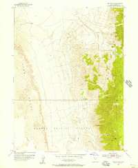
1955 Map of Wig Mtn NE
USGS Topo · Published 1957About this map
Dugway Proving Ground dominates the southern reaches of this landscape, reflecting the mid-century expansion of military testing sites across the Great Salt Lake Desert. The eastern portion of the sheet is defined by the high ridges of the Cedar Mountains, where isolated water sources like Browns Spring and Cedar Spring provided vital points for travelers and livestock in an arid environment. These mountains are bisected by significant topographic breaks, including Six Horse Pass and the deep cuts of Rydalch Canyon.
Find a feature on this map
12 named features on this map. Tap any name to fly to it.
Don’t see what you’re looking for? This feature index may not catch every label — zoom into the map to look around manually.
Map Details
Editions of this 1955 Wig Mtn NE Map
4 editions found
Other maps of this area

1885 · Tooele Valley
USGS Topo · 1:250,000

1953 · Tooele
USGS Topo · 1:250,000

1954 · Wig Mtn SW
USGS Topo · 1:24,000

1954 · Wig Mtn NW
USGS Topo · 1:24,000

1955 · Tabbys Peak
USGS Topo · 1:24,000

1955 · Wig Mtn
USGS Topo · 1:24,000

1955 · Wig Mtn NE
USGS Topo · 1:24,000

1955 · Tabbys Peak SW
USGS Topo · 1:24,000

1955 · Tooele
USGS Topo · 1:250,000

1973 · Quincy Spring
USGS Topo · 1:24,000