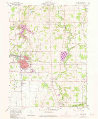
1960 Map of Willard
USGS Topo · Published 1973About this map
The rail-oriented town of Willard serves as the focal point for this area within the Connecticut Western Reserve, where the Baltimore and Ohio railroad corridor shapes the local geography. Just south of the main settlement, Celeryville anchors a unique agricultural district defined by the Marsh Run drainage, while the southern boundary includes a portion of Plymouth. The map captures the transition from mid-century industrial expansion to the early 1970s, with updates showing the growth of Willard Airport and residential developments around the High Sch and St Josephs Ch. A network of rural township roads, such as Townline Road and Egypt Road, connects outlying hamlets like Steuben and Boughtonville. Notable rural landmarks include the Greenwood Cem and Guinea Corners Ch, reflecting the deep-rooted community history of the Greenfield and New Haven townships.
Find a feature on this map
56 named features on this map. Tap any name to fly to it.
Don’t see what you’re looking for? This feature index may not catch every label — zoom into the map to look around manually.
Map Details
Editions of this 1960 Willard Map
3 editions found
Other maps of this area

1915 · Norwalk
USGS Topo · 1:62,500

1915 · Siam
USGS Topo · 1:62,500

1915 · Bucyrus
USGS Topo · 1:62,500

1915 · Crestline
USGS Topo · 1:62,500

1943 · Bucyrus
USGS Topo · 1:62,500

1943 · Crestline
USGS Topo · 1:62,500

1944 · Norwalk
USGS Topo · 1:62,500

1950 · Marion
USGS Topo · 1:250,000

1956 · Toledo
USGS Topo · 1:250,000

1960 · Willard
USGS Topo · 1:24,000