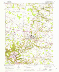
1968 Map of Williamsburg
USGS Topo · Published 1976About this map
The East Fork Little Miami River winds sharply through this 1968 landscape, marking a period of transition before the full inundation of the lake. The village of Williamsburg sits as the central hub, surrounded by a network of rural settlements like Blowville, Afton, and Crosstown. These communities are connected by the Norfolk and Western railroad and historic routes such as the Mc Keever Schoolhouse Road. Notable for local genealogists are the family-named features and rural institutions, including Hennings Mill, Maple Grove Ch, and the Greenberry Sch. Purple revisions from 1974 indicate planned changes near Elk Lick and the rising waters of the East Fork, showing the footprint of Lake O' the Woods before the valley's character was permanently altered by regional water projects.
Find a feature on this map
70 named features on this map. Tap any name to fly to it.
Don’t see what you’re looking for? This feature index may not catch every label — zoom into the map to look around manually.
Map Details
Editions of this 1968 Williamsburg Map
4 editions found
Other maps of this area

1914 · Batavia
USGS Topo · 1:48,000

1916 · Batavia
USGS Topo · 1:62,500

1917 · Sardinia
USGS Topo · 1:62,500

1928 · Higginsport
USGS Topo · 1:48,000

1931 · Felicity
USGS Topo · 1:62,500

1931 · Higginsport
USGS Topo · 1:62,500

1944 · Sardinia
USGS Topo · 1:62,500

1947 · Columbus
USGS Topo · 1:250,000

1953 · Laurel
USGS Topo · 1:24,000

1953 · Bethel
USGS Topo · 1:24,000