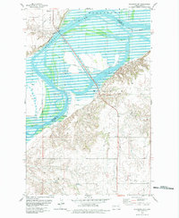
1979 Map of Williston SW
USGS Topo · Published 1979About this map
The Missouri River dominates this landscape along the border of Williams and McKenzie Counties, carving through the northwestern plains. In the late 1970s, the river valley reveals a complex interplay of natural drainage and human infrastructure, featuring multiple Gaging Stations to monitor the waterway. The Burlington Northern railroad tracks parallel the river's course, supporting the transport needs of a region defined by agricultural townships like Wilbur, Elk, and Foe. Evidence of the area's pioneer and military history is preserved through the Old Military Reservation Boundary, which cuts across the terrain south of the river. Small community landmarks such as Rosseland Ch and the Radio Towers (KEZY) serve as anchors for the rural population in Judson and Trenton townships during this era.
Find a feature on this map
14 named features on this map. Tap any name to fly to it.
Don’t see what you’re looking for? This feature index may not catch every label — zoom into the map to look around manually.
Map Details
Editions of this 1979 Williston SW Map
This is the sole edition of this map. No revisions or reprints were ever made.
Other maps of this area

1953 · Williston
USGS Topo · 1:250,000

1953 · Watford City
USGS Topo · 1:250,000

1957 · Williston
USGS Topo · 1:250,000

1957 · Watford City
USGS Topo · 1:250,000

1959 · Williston West
USGS Topo · 1:24,000

1959 · Williston East
USGS Topo · 1:24,000

1967 · Watford City
USGS Topo · 1:250,000

1969 · Trenton
USGS Topo · 1:24,000

1969 · Cartwright NE
USGS Topo · 1:24,000

1974 · Trenton NE
USGS Topo · 1:24,000