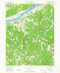
1957 Map of Willow Island
USGS Topo · Published 1967About this map
Willow Island and the industrial corridor along the Ohio River define the northern edge of this 1957 topographic survey. The landscape transitions quickly from the river valley and the Baltimore and Ohio railroad tracks into the steep, dissected ridges of Grant and Jefferson districts. This area is heavily marked by the extraction industry, with dozens of Oil Wells peppered across the hillsides, particularly near Volcano and Newlandsville.
Find a feature on this map
62 named features on this map. Tap any name to fly to it.
Don’t see what you’re looking for? This feature index may not catch every label — zoom into the map to look around manually.
Map Details
Editions of this 1957 Willow Island Map
3 editions found
Other maps of this area

1904 · Marietta
USGS Topo · 1:62,500

1906 · Saint Marys
USGS Topo · 1:62,500

1906 · Elizabeth
USGS Topo · 1:62,500

1907 · Harrisville
USGS Topo · 1:62,500

1924 · St Marys
USGS Topo · 1:62,500

1924 · Harrisville
USGS Topo · 1:62,500

1924 · Marietta
USGS Topo · 1:62,500

1924 · Elizabeth
USGS Topo · 1:62,500

1926 · Elizabeth
USGS Topo · 1:62,500

1926 · Harrisville
USGS Topo · 1:62,500