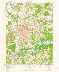
1962 Map of Wills Creek
USGS Topo · Published 1963About this map
Wills Creek Reservoir dominates the landscape of this early 1960s survey, representing the massive water management efforts of the Muskingum Conservancy District Watershed. The Wills Creek Dam regulates the flow of Wills Creek just south of the small village of Wills Creek. Heavy extraction industry is a defining characteristic of the era, visible in the extensive Strip Mine operations and gravel pits that carve into the hills of Franklin and Linton townships. Cultural history is preserved through numerous family and congregational sites like Our Lady of Lourdes Ch Cem and St Pauls Ch. The presence of the Pennsylvania and New York railroads, along with an industrial Conveyor, highlights the intersection of transportation and the local mining economy during this period of development in the United States Military District.
Find a feature on this map
51 named features on this map. Tap any name to fly to it.
Don’t see what you’re looking for? This feature index may not catch every label — zoom into the map to look around manually.
Map Details
Editions of this 1962 Wills Creek Map
4 editions found
Other maps of this area

1908 · Conesville
USGS Topo · 1:62,500

1909 · Cambridge
USGS Topo · 1:62,500

1910 · Conesville
USGS Topo · 1:62,500

1911 · Newcomerstown
USGS Topo · 1:62,500

1912 · Cambridge
USGS Topo · 1:62,500

1913 · Newcomerstown
USGS Topo · 1:62,500

1913 · Coshocton
USGS Topo · 1:62,500

1915 · Coshocton
USGS Topo · 1:62,500

1943 · Coshocton
USGS Topo · 1:62,500

1943 · Newcomerstown
USGS Topo · 1:62,500
Featured Places
- Coshocton, OH
- Bacon, Linton Township
- Lafayette Township, OH
- Franklin Township, OH
- Wills Creek, Franklin Township