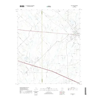
2019 Map of Wills Point
USGS Topo · Published 2019About this map
Wills Point serves as the primary hub of this 2019 survey, showing the established town layout and surrounding rural settlements like Hiram and Cobb. The landscape is defined by the Kaufman Co Van Zandt Co border, which cuts through a terrain dominated by numerous watercourses including Rocky Cedar Creek, Wolf Cr, and Blackberry Cr. Genealogists will find a significant density of historical burial sites throughout the countryside, such as New Salem Cem, Locust Grove Cem, and Allen Cem. The proximity of these cemeteries to small communities and farm roads suggests a long-standing pattern of family-centered settlement in this part of Northeast Texas. While the northern section includes the Richie Rich Airport, much of the area remains oriented around the intricate network of county roads and creek beds like Little Allen Cr and McBee Cr, reflecting a landscape that balances early homestead heritage with modern transportation corridors.
Find a feature on this map
102 named features on this map. Tap any name to fly to it.
Don’t see what you’re looking for? This feature index may not catch every label — zoom into the map to look around manually.
Map Details
Editions of this 2019 Wills Point Map
This is the sole edition of this map. No revisions or reprints were ever made.
Other maps of this area

1954 · Dallas
USGS Topo · 1:250,000

1956 · Tyler
USGS Topo · 1:250,000

1956 · Quinlan
USGS Topo · 1:62,500

1956 · Emory
USGS Topo · 1:62,500

1958 · Dallas
USGS Topo · 1:250,000

1962 · Myrtle Springs
USGS Topo · 1:24,000

1962 · Elmo
USGS Topo · 1:24,000

1962 · Cedarvale
USGS Topo · 1:24,000

1962 · Wills Point
USGS Topo · 1:24,000
1962 · Ola
USGS Topo · 1:24,000