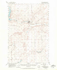
1956 Map of Wilson Creek
USGS Topo · Published 1972About this map
The town of Wilson Creek sits at the confluence of several critical waterways and transportation routes, serving as a focal point for this high desert landscape. Settled in the Wilson Creek Valley, the community is defined by its proximity to the Great Northern railroad and the winding course of Crab Creek. The map reveals a complex hydraulic system managed by the Bureau of Reclamation, featuring an intricate network of infrastructure including a siphon, levee, and canal systems that redirect water through the Coulee country.
Find a feature on this map
27 named features on this map. Tap any name to fly to it.
Don’t see what you’re looking for? This feature index may not catch every label — zoom into the map to look around manually.
Map Details
Editions of this 1956 Wilson Creek Map
2 editions found

Other maps of this area

1912 · Moses Lake
USGS Topo · 1:62,500

1923 · Wheeler
USGS Topo · 1:62,500

1925 · Wheeler
USGS Topo · 1:62,500

1925 · Schrag
USGS Topo · 1:62,500

1953 · Ritzville
USGS Topo · 1:250,000

1956 · Wheeler
USGS Topo · 1:24,000

1956 · Stratford
USGS Topo · 1:24,000

1956 · Moses Lake North
USGS Topo · 1:24,000

1956 · Gloyd
USGS Topo · 1:24,000

1956 · Wilson Creek SW
USGS Topo · 1:24,000