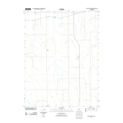
2011 Map of Wilsonville NW
USGS Topo · Published 2011About this map
Tyrone Cemetery stands near the southern edge of this Red Willow County landscape, serving as a quiet focal point for local genealogical interest. The region is defined by its agricultural water management, most notably the Bartley Canal which cuts across the northern terrain, and the Kleckner Reservoir secured by Kleckner Dam. This 2011 survey reflects a rural educational heritage, marking the locations of the Plainview School Number 62 and East Valley School. The drainage patterns of Silver Creek and Johnson Creek intersect with a grid of section roads, including Road 719 and Dr 716, while the evocative Bogus Canyon breaks the prairie surface. The map documents a sparsely populated but systematically organized territory where every schoolhouse site and water feature tells the story of high plains settlement and ranching.
Find a feature on this map
16 named features on this map. Tap any name to fly to it.
Don’t see what you’re looking for? This feature index may not catch every label — zoom into the map to look around manually.
Map Details
Editions of this 2011 Wilsonville NW Map
This is the sole edition of this map. No revisions or reprints were ever made.
Other maps of this area

1954 · McCook
USGS Topo · 1:250,000

1956 · Cambridge
USGS Topo · 1:24,000

1956 · Bartley
USGS Topo · 1:24,000

1957 · McCook
USGS Topo · 1:250,000

1957 · Shippee
USGS Topo · 1:24,000
1957 · Wilsonville
USGS Topo · 1:24,000

1957 · Lebanon
USGS Topo · 1:24,000

1957 · Danbury NE
USGS Topo · 1:24,000

1958 · McCook
USGS Topo · 1:250,000

1958 · Danbury NE
USGS Topo · 1:24,000