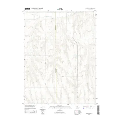
2014 Map of Wilsonville NW
USGS Topo · Published 2014About this map
Tyrone Cem sits near the southern border of this landscape, marking a point of quiet history in an area defined by agricultural water management and prairie drainage. The northern reaches are characterized by the Bartley Canal, which cuts across the terrain near Silver Cr and the topographical depression of Bogus Canyon. This survey illustrates the intricate relationship between the region's draws and the man-made irrigation infrastructure that supports the surrounding farmsteads. The landscape is a transition between the uplands of Red Willow County and Furnas County, with the Kleckner Reservoir serving as a prominent landmark in the central-east section. Secondary drainages such as Johnson Cr further define the undulating contours of this rural Nebraska quadrangle.
Find a feature on this map
17 named features on this map. Tap any name to fly to it.
Don’t see what you’re looking for? This feature index may not catch every label — zoom into the map to look around manually.
Map Details
Editions of this 2014 Wilsonville NW Map
This is the sole edition of this map. No revisions or reprints were ever made.
Other maps of this area

1954 · McCook
USGS Topo · 1:250,000

1956 · Cambridge
USGS Topo · 1:24,000

1956 · Bartley
USGS Topo · 1:24,000

1957 · McCook
USGS Topo · 1:250,000

1957 · Shippee
USGS Topo · 1:24,000
1957 · Wilsonville
USGS Topo · 1:24,000

1957 · Lebanon
USGS Topo · 1:24,000

1957 · Danbury NE
USGS Topo · 1:24,000

1958 · McCook
USGS Topo · 1:250,000

1958 · Danbury NE
USGS Topo · 1:24,000