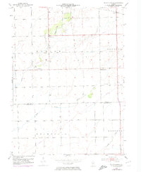
1953 Map of Wilton Center
USGS Topo · Published 1974About this map
Wilton Center and the surrounding agricultural landscape of Will Co and Kankakee Co are captured here in a period of mid-century stability. The map highlights the intersection of local faith and memory through landmarks like St Patricks Ch and several burial grounds, including Wilton Cem, Calvary Cem, and West Peotone Cem. The drainage patterns of Forked Creek, Rock Creek, and the South Branch indicate a rural prairie terrain managed for cultivation, while the inclusion of Gerdes Woods preserves a remnant of the area's natural timber.
Find a feature on this map
19 named features on this map. Tap any name to fly to it.
Don’t see what you’re looking for? This feature index may not catch every label — zoom into the map to look around manually.
Map Details
Editions of this 1953 Wilton Center Map
2 editions found

Other maps of this area

1892 · Wilmington
USGS Topo · 1:62,500

1918 · Wilmington
USGS Topo · 1:62,500

1922 · Kankakee
USGS Topo · 1:62,500

1923 · Herscher
USGS Topo · 1:62,500

1924 · Kankakee
USGS Topo · 1:62,500

1925 · Herscher
USGS Topo · 1:62,500

1929 · Brisbane
USGS Topo · 1:24,000

1930 · Frankfort
USGS Topo · 1:24,000

1949 · Peotone
USGS Topo · 1:62,500

1953 · Peotone
USGS Topo · 1:24,000