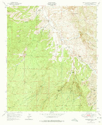
1950 Map of Wind Mountain
USGS Topo · Published 1975About this map
Gila National Forest encompasses the rugged western portion of this terrain, where steep drainages like Sawmill Canyon and Maverick Canyon descend from high ridges. The landscape is a complex network of ranching outposts and active mineral extraction sites typical of New Mexico's mining history. High points such as Wind Mountain and Sugarloaf Mtn dominate the horizon, while the Continental Divide traverses the southern reaches near Copper Mtn.
Find a feature on this map
47 named features on this map. Tap any name to fly to it.
Don’t see what you’re looking for? This feature index may not catch every label — zoom into the map to look around manually.
Map Details
Editions of this 1950 Wind Mountain Map
3 editions found
Other maps of this area

1909 · Silver City
USGS Topo · 1:125,000

1949 · Circle Mesa
USGS Topo · 1:24,000

1950 · Tyrone
USGS Topo · 1:24,000

1950 · White Signal
USGS Topo · 1:24,000

1950 · Wind Mountain
USGS Topo · 1:24,000

1950 · Burro Peak
USGS Topo · 1:24,000

1950 · Silver City
USGS Topo · 1:24,000

1951 · Circle Mesa
USGS Topo · 1:24,000

1951 · White Signal
USGS Topo · 1:24,000
1951 · Silver City
USGS Topo · 1:24,000