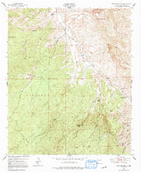
1950 Map of Wind Mountain
USGS Topo · Published 1991About this map
Wind Mountain dominates this portion of the New Mexico landscape, a high point in a region defined by the complex topography of the Gila National Forest. In the mid-twentieth century, the area was a hub of active mineral extraction, evidenced by the Shrine Mine (Active) and numerous others such as the Black Hawk Mines, Ohio Mine, and Turquoise Mine. The map reveals a pattern of isolated ranching and mining life, where the Continental Divide winds through the southern ridges near the Samson Mine. Water sources were critical for both industry and livestock, centered around features like Mangas Creek, Willow Creek, and several named springs. Cultural landmarks are also documented, including an Indian Burial Ground and various family holdings like Fleming Ranch and Kaufman Ranch.
Find a feature on this map
50 named features on this map. Tap any name to fly to it.
Don’t see what you’re looking for? This feature index may not catch every label — zoom into the map to look around manually.
Map Details
Editions of this 1950 Wind Mountain Map
3 editions found
Other maps of this area

1909 · Silver City
USGS Topo · 1:125,000

1949 · Circle Mesa
USGS Topo · 1:24,000

1950 · Tyrone
USGS Topo · 1:24,000

1950 · White Signal
USGS Topo · 1:24,000

1950 · Wind Mountain
USGS Topo · 1:24,000

1950 · Burro Peak
USGS Topo · 1:24,000

1950 · Silver City
USGS Topo · 1:24,000

1951 · Circle Mesa
USGS Topo · 1:24,000

1951 · White Signal
USGS Topo · 1:24,000
1951 · Silver City
USGS Topo · 1:24,000