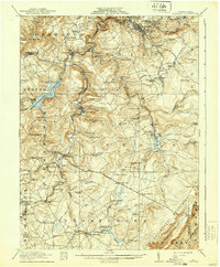
1916 Map of Windber
USGS Topo · Published 1939About this map
Windber and the coal-rich highlands of Somerset County dominate this topographic study, surveyed just before the First World War. The landscape is defined by the sharp descent from the Allegheny Mountains in the east toward the industrial valleys of Stony Creek and Quemahoning Creek. The presence of the Old Shade Furnace and Sinne Sawmill points to the region's early industrial roots in iron and timber, while the sprawling Quemahoning Reservoir and numerous rail spurs like the Jerome Junc reflect the massive infrastructure required for early 20th-century coal extraction. Local life is densely mapped through family-named landmarks and rural institutions, including the Kaufman School, Berkey Church, and the high-elevation settlement at Reels Corners. The map provides a detailed view of the complex rail network of the Pennsylvania RR and Baltimore and Ohio RR as they navigated the steep gaps and narrow runs of the Allegheny front.
Find a feature on this map
120 named features on this map. Tap any name to fly to it.
Don’t see what you’re looking for? This feature index may not catch every label — zoom into the map to look around manually.
Map Details
Editions of this 1916 Windber Map
4 editions found

Other maps of this area

1902 · Ebensburg
USGS Topo · 1:62,500

1904 · Ebensburg
USGS Topo · 1:62,500

1904 · Johnstown
USGS Topo · 1:62,500

1907 · Johnstown
USGS Topo · 1:62,500

1908 · Bedford
USGS Topo · 1:62,500

1910 · Bedford
USGS Topo · 1:62,500

1913 · Somerset
USGS Topo · 1:62,500

1914 · Windber
USGS Topo · 1:62,500

1915 · Somerset
USGS Topo · 1:62,500

1916 · Windber
USGS Topo · 1:62,500