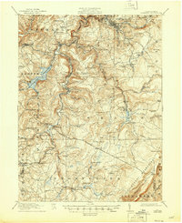
1916 Map of Windber
USGS Topo · Published 1945About this map
Windber anchors this industrial and agricultural landscape of Somerset County, shown here during a period of significant growth for the regional coal and timber industries. The map illustrates a complex network of transportation, including the Pennsylvania RR and the Baltimore and Ohio RR, which serviced the scattered mining settlements and boroughs. Water management and early industry are prominent, from the expanse of the Quemahoning Reservoir to legacy sites like the Old Shade Furnace and Stone Sawmill. Local history is deeply etched into the terrain through numerous family-named schools and churches, such as the Kaufman School and Berkey Church, reflecting the established community nodes of the early twentieth century. The topography transitions from the valley floors of Stony Creek and Shade Creek up toward the Allegheny Mountains in the southeast.
Find a feature on this map
113 named features on this map. Tap any name to fly to it.
Don’t see what you’re looking for? This feature index may not catch every label — zoom into the map to look around manually.
Map Details
Editions of this 1916 Windber Map
4 editions found

Other maps of this area

1902 · Ebensburg
USGS Topo · 1:62,500

1904 · Ebensburg
USGS Topo · 1:62,500

1904 · Johnstown
USGS Topo · 1:62,500

1907 · Johnstown
USGS Topo · 1:62,500

1908 · Bedford
USGS Topo · 1:62,500

1910 · Bedford
USGS Topo · 1:62,500

1913 · Somerset
USGS Topo · 1:62,500

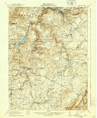
1914 · Windber
USGS Topo · 1:62,500

1915 · Somerset
USGS Topo · 1:62,500

1916 · Windber
USGS Topo · 1:62,500