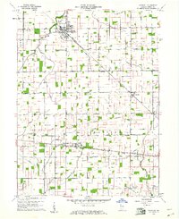
1960 Map of Windfall
USGS Topo · Published 1961About this map
Windfall sits at the northern end of this central Indiana landscape, defined by a dense network of drainage channels such as Wildcat Creek and Rodgers Ditch. This 1960 field-checked survey reveals an agricultural environment organized around the Pennsylvania RR, which cuts diagonally through the townships of Liberty and Wildcat. The map records several small rail-side communities, including Curtisville and Hobbs, the latter positioned along the New York Chicago and St Louis RR. Local history is anchored by rural institutions like Hazeldell Ch and several burial grounds, including Brookside Cemetery and the more remote Sandbank Cem. The sheer number of named ditches—from Askren Ditch to Myerly Hobbs Ditch—highlights the intensive effort required to manage the flat, productive plains of Tipton County during this era of mid-century farming.
Find a feature on this map
53 named features on this map. Tap any name to fly to it.
Don’t see what you’re looking for? This feature index may not catch every label — zoom into the map to look around manually.
Map Details
Editions of this 1960 Windfall Map
2 editions found
Other maps of this area

1953 · Danville
USGS Topo · 1:250,000

1953 · Muncie
USGS Topo · 1:250,000

1955 · Danville
USGS Topo · 1:250,000

1956 · Muncie
USGS Topo · 1:250,000

1956 · Danville
USGS Topo · 1:250,000

1960 · Elwood
USGS Topo · 1:24,000

1960 · Point Isabel
USGS Topo · 1:24,000

1960 · Kokomo East
USGS Topo · 1:24,000

1960 · Tipton
USGS Topo · 1:24,000

1960 · Windfall
USGS Topo · 1:24,000