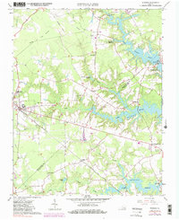
1965 Map of Windsor
USGS Topo · Published 1985About this map
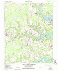
Windsor stands as a vital crossroads in Isle of Wight County, defined by its position along the Norfolk and Western railway and its surrounding network of swamps and reservoirs. The landscape is a transition from established agriculture and small settlements like Indika and Everetts to the engineered hydrology of Lake Prince and Burnt Mills Lake, which dominate the eastern terrain. This mid-century view shows the coexistence of traditional rural life—evidenced by local landmarks like Woodland Ch and Mt Zion Cem—with modern infrastructure including an aqueduct and multiple pipelines. Researchers can trace the legacy of timber and water management through the many swamp systems, such as Ennis Swamp and Eley Swamp, and find evidence of older transportation routes like the Old Railroad Grade north of town.
Find a feature on this map
45 named features on this map. Tap any name to fly to it.
Don’t see what you’re looking for? This feature index may not catch every label — zoom into the map to look around manually.
Map Details
Editions of this 1965 Windsor Map
5 editions found
Other maps of this area

1919 · Smithfield
USGS Topo · 1:62,500

1919 · Suffolk
USGS Topo · 1:62,500

1920 · Holland
USGS Topo · 1:62,500

1920 · Ivor
USGS Topo · 1:62,500

1943 · Holland
USGS Topo · 1:62,500

1944 · Windsor
USGS Topo · 1:31,680

1944 · Smithfield
USGS Topo · 1:24,000

1944 · Raynor
USGS Topo · 1:24,000

1944 · Zuni
USGS Topo · 1:24,000

1945 · Zuni
USGS Topo · 1:31,680