1955 Map of Windsor
USGS Topo · Published 1956About this map
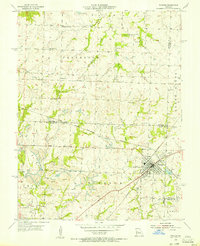
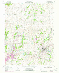
The railroad town of Windsor serves as a central hub where the Missouri Kansas and Texas and the Chicago Rock Island and Pacific lines intersect. This 1955 survey illustrates a landscape undergoing industrial transition, characterized by extensive Strip Mine operations and mines dotting the hillsides, particularly around Bowen and north of the main settlement. The agrarian foundations of the county remain visible through a dense network of local institutions, including High Point Ch and several rural schoolhouses like Valley Grove Sch and Hillside Sch. In Windsor, the Windsor Fairgrounds and Farrington Park provide community focal points, while numerous family and community cemeteries like Laurel Oak Cem and Chipman Cem offer significant data for genealogists. The terrain is defined by the winding paths of Tebo Creek and its forks, which cut through the coal-rich lands of Henry and Johnson counties.
Find a feature on this map
45 named features on this map. Tap any name to fly to it.
Don’t see what you’re looking for? This feature index may not catch every label — zoom into the map to look around manually.
Map Details
Editions of this 1955 Windsor Map
2 editions found
Other maps of this area

1885 · Warrensburg
USGS Topo · 1:125,000

1887 · Clinton
USGS Topo · 1:125,000

1887 · Sedalia
USGS Topo · 1:125,000

1887 · Warsaw
USGS Topo · 1:125,000

1887 · Warrensburg
USGS Topo · 1:125,000

1894 · Warsaw
USGS Topo · 1:125,000

1894 · Sedalia
USGS Topo · 1:125,000

1894 · Warrensburg
USGS Topo · 1:125,000

1894 · Clinton
USGS Topo · 1:125,000

1947 · Jefferson City
USGS Topo · 1:250,000