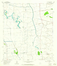
1962 Map of Winnie NW
USGS Topo · Published 1964About this map
The low-lying wetlands of Jefferson, Liberty, and Chambers Counties define this 1962 survey, where a complex network of man-made waterways like the Lower Neches Valley Authority Canal and Nolte Canal cut across the coastal prairie. These hydraulic engineering projects intersect with natural drainages such as Spindletop Bayou and Taylor Bayou, illustrating the mid-century transformation of the Texas Gulf Coast for agricultural irrigation and industrial use.
Find a feature on this map
39 named features on this map. Tap any name to fly to it.
Don’t see what you’re looking for? This feature index may not catch every label — zoom into the map to look around manually.
Map Details
Editions of this 1962 Winnie NW Map
2 editions found
Other maps of this area

1943 · Whites Bayou
USGS Topo · 1:24,000

1943 · Liberty
USGS Topo · 1:125,000

1943 · Stowell
USGS Topo · 1:24,000

1945 · Nolte
USGS Topo · 1:31,680

1950 · Houston
USGS Topo · 1:250,000

1954 · Beaumont
USGS Topo · 1:250,000

1955 · Daisetta
USGS Topo · 1:62,500

1955 · Sour Lake
USGS Topo · 1:62,500

1956 · Houston
USGS Topo · 1:250,000

1957 · Beaumont
USGS Topo · 1:250,000