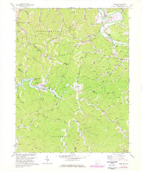
1972 Map of Winslow
USGS Topo · Published 1977About this map
The Guyandotte River and the Ohio River converge in this transition landscape where West Virginia's rugged terrain meets organized industry. In the early 1970s, the development of Beech Fork Lake was underway, significantly altering the drainage patterns of Beech Fork and its tributaries like Moxley Br. The map reveals a high density of gas production, with scores of Gas Wells punctuating the ridges and valleys between small communities like Winslow and Sarah. Transportation and infrastructure are anchored by the Chesapeake and Ohio RR and an extensive network of pipelines. Local history is preserved in rural landmarks such as Mays Chapel, Davis Chapel, and the McComas Sch, while recreation is represented by Camp Dekanawida and the local Golf Course.
Find a feature on this map
59 named features on this map. Tap any name to fly to it.
Don’t see what you’re looking for? This feature index may not catch every label — zoom into the map to look around manually.
Map Details
Editions of this 1972 Winslow Map
4 editions found
Other maps of this area

1892 · Huntington
USGS Topo · 1:125,000

1898 · Huntington
USGS Topo · 1:125,000

1901 · Guyandot
USGS Topo · 1:62,500

1902 · Guyandot
USGS Topo · 1:62,500

1902 · Milton
USGS Topo · 1:62,500

1902 · Midkiff
USGS Topo · 1:62,500

1907 · Midkiff
USGS Topo · 1:62,500

1909 · Wayne
USGS Topo · 1:62,500

1909 · Midkiff
USGS Topo · 1:62,500

1931 · Wayne
USGS Topo · 1:62,500