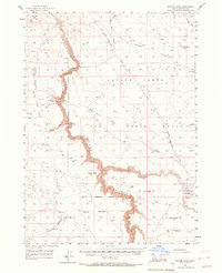
1956 Map of Winter Camp
USGS Topo · Published 1967About this map
Bruneau River and its dramatic East Fork Bruneau Canyon dominate this high-desert landscape in Owyhee County. The survey illustrates a stark geography where steep canyon walls drop away from flat mesas like Miller Table and Big Hill. Significant military presence is noted by the Saylor Creek Air Force Range and its associated Military Reservation Boundary, which spans a large portion of the eastern and central terrain.
Find a feature on this map
34 named features on this map. Tap any name to fly to it.
Don’t see what you’re looking for? This feature index may not catch every label — zoom into the map to look around manually.
Map Details
Editions of this 1956 Winter Camp Map
2 editions found

Other maps of this area

1947 · Bruneau
USGS Topo · 1:62,500

1947 · Sugar Valley
USGS Topo · 1:24,000

1947 · Hot Spring
USGS Topo · 1:24,000

1948 · Sugar Valley
USGS Topo · 1:24,000

1948 · Indian Cove
USGS Topo · 1:62,500

1948 · Glenns Ferry
USGS Topo · 1:62,500

1948 · Pence Butte
USGS Topo · 1:24,000
1949 · Pot Hole Canyon
USGS Topo · 1:24,000
1949 · Pence Butte
USGS Topo · 1:24,000
1949 · Hot Spring
USGS Topo · 1:24,000