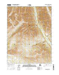
2016 Map of Wiseman A-5 NW
USGS Topo · Published 2016About this map
The Malamute Fork is the primary waterway in this 2016 survey of the Alaskan interior, showing the headwaters and drainage patterns of the Yukon-Koyukuk region. In a landscape defined by significant elevation changes and deep valleys, the map details the confluence of various tributaries such as Midas Cr and Jones Cr. These drainage paths provide an essential look at the physical geography before it joins larger systems downstream. The intricate contour work illustrates the steep ridges and basins that separate Bedrock Cr from neighboring watersheds within the boundaries of t28n r22w and t27n r22w. This topographic study is focused entirely on the natural hydrography and terrain of the Brooks Range foothills, showing a region where names are tied almost exclusively to the shifting waters of the creek beds.
Find a feature on this map
8 named features on this map. Tap any name to fly to it.
Don’t see what you’re looking for? This feature index may not catch every label — zoom into the map to look around manually.
Map Details
Editions of this 2016 Wiseman A-5 NW Map
This is the sole edition of this map. No revisions or reprints were ever made.
Other maps of this area

1951 · Wiseman
USGS Topo · 1:250,000

1956 · Wiseman
USGS Topo · 1:250,000

1964 · Wiseman
USGS Topo · 1:250,000
1970 · Wiseman A-6
USGS Topo · 1:63,360

1970 · Wiseman A-5
USGS Topo · 1:63,360
1971 · Wiseman B-5
USGS Topo · 1:63,360
1986 · Wiseman B-6
USGS Topo · 1:63,360
2016 · Wiseman B-5 SW
USGS Topo · 1:25,000
2016 · Wiseman A-5 SE
USGS Topo · 1:25,000
2016 · Wiseman A-5 SW
USGS Topo · 1:25,000