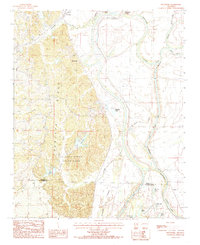
1984 Map of Wittsburg
USGS Topo · Published 1985About this map
Crowleys Ridge rises dramatically above the Arkansas Delta, creating a stark geological contrast between the elevated upland terrain and the adjacent river bottomlands. This 1980s landscape is defined by the managed waters of the St Francis River and the St Francis Floodway, which together shape the drainage and geography along the border of Cross and St. Francis Counties. The settlement at Wittsburg and the northern community of Levesque sit at the western edge of this transition, where the ridge's unique topography provided a refuge from the seasonal flooding of the delta.
Find a feature on this map
32 named features on this map. Tap any name to fly to it.
Don’t see what you’re looking for? This feature index may not catch every label — zoom into the map to look around manually.
Map Details
Editions of this 1984 Wittsburg Map
2 editions found
Other maps of this area

1939 · Vanndale
USGS Topo · 1:62,500

1939 · Wynne
USGS Topo · 1:62,500

1940 · Princedale
USGS Topo · 1:62,500

1940 · Whitmore
USGS Topo · 1:62,500

1953 · Memphis
USGS Topo · 1:250,000

1956 · Memphis
USGS Topo · 1:250,000

1956 · Whitmore
USGS Topo · 1:62,500

1956 · Princedale
USGS Topo · 1:62,500

1958 · Wynne
USGS Topo · 1:62,500

1958 · Vanndale
USGS Topo · 1:62,500