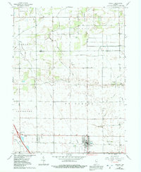
1962 Map of Wolcott
USGS Topo · Published 1991About this map
Agricultural drainage and early transportation networks dominate this landscape along the Jasper Co White Co border in the early 1960s. The town of Wolcott serves as the primary hub, situated near the intersection of modern highway infrastructure and traditional rural landmarks. The importance of land reclamation for farming is evident in the intricate network of artificial waterways, including Bice Ditch, Keefe Ditch, and Nesius DITCH, which crisscross the townships of Princeton, Milroy, and Carpenter. Local genealogy is well-represented through numerous burial grounds such as Milroy Cem and Dobbins Cem, as well as community steeples like Palestine Ch and Mt Zion Ch. The transition toward modern travel is marked by Interchange 201 and a local Landing Strip, illustrating how this Indiana prairie evolved to support both intensive cultivation and growing regional connectivity.
Find a feature on this map
24 named features on this map. Tap any name to fly to it.
Don’t see what you’re looking for? This feature index may not catch every label — zoom into the map to look around manually.
Map Details
Editions of this 1962 Wolcott Map
3 editions found
Other maps of this area

1953 · Danville
USGS Topo · 1:250,000

1955 · Danville
USGS Topo · 1:250,000

1956 · Danville
USGS Topo · 1:250,000

1962 · Mount Gilboa
USGS Topo · 1:24,000

1962 · Templeton NE
USGS Topo · 1:24,000

1962 · Brookston NW
USGS Topo · 1:24,000

1962 · Monon
USGS Topo · 1:24,000
1962 · Francesville
USGS Topo · 1:24,000
1962 · Mc Coysburg
USGS Topo · 1:24,000
1962 · Rensselaer
USGS Topo · 1:24,000