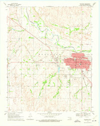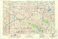
1955 Map of Woodward
USGS Topo · Published 1973About this map
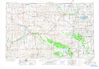
Woodward and Alva anchor this mid-century look at the High Plains and Red Bed Plains of Northwest Oklahoma. The landscape is defined by the braided paths of the Cimarron River, North Canadian River, and Salt Fork Arkansas River, which supported a network of agriculture and energy extraction. Extensive Oil and Gas Fields are mapped throughout the region, particularly concentrated near Cherokee and Waynoka. The presence of the Atchison Topeka and Santa Fe and Chicago Rock Island and Pacific railroads highlights the vital transportation corridors that linked these prairie towns to larger markets.
Find a feature on this map
183 named features on this map. Tap any name to fly to it.
Don’t see what you’re looking for? This feature index may not catch every label — zoom into the map to look around manually.
Map Details
Editions of this 1955 Woodward Map
3 editions found

Historical Maps of Woodward Through Time
9 maps found