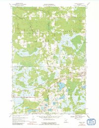
1970 Map of Wright
USGS Topo · Published 1991About this map
Wright sits at the junction of State Highway 210 and the Burlington Northern railroad, serving as a focal point for the surrounding wetlands and forests of eastern Minnesota. The landscape is defined by an intricate network of water bodies and marshlands, including Cole Lake, Mattila Lake, and the winding Tamarack River. To the west, the Savanna State Forest covers a significant portion of the terrain, while the Aitkin and Carlton County line bisects the wilderness. The map reveals the local importance of naming even small features, with many lakes bearing family-derived names such as Louma Lake and Walli Lake. Public landmarks like the Lakeside Cem near Kettle Lake and a Picnic Area on the northern shore of Cole Lake provide evidence of the area's community structure amidst the extensive glacial topography.
Find a feature on this map
32 named features on this map. Tap any name to fly to it.
Don’t see what you’re looking for? This feature index may not catch every label — zoom into the map to look around manually.
Map Details
Editions of this 1970 Wright Map
2 editions found
Other maps of this area

1953 · Duluth
USGS Topo · 1:250,000

1958 · Duluth
USGS Topo · 1:250,000

1961 · Cromwell
USGS Topo · 1:62,500

1963 · Prairie Lake
USGS Topo · 1:24,000

1969 · Automba
USGS Topo · 1:24,000

1969 · Lawler
USGS Topo · 1:24,000

1970 · Tamarack
USGS Topo · 1:24,000

1970 · Little Prairie Lake
USGS Topo · 1:24,000

1970 · Balsam
USGS Topo · 1:24,000

1970 · Wright
USGS Topo · 1:24,000