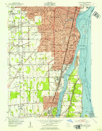
1952 Map of Wyandotte
USGS Topo · Published 1954About this map
Industrial developments along the Detroit River characterize this mid-century look at the downriver communities south of Detroit. The landscape is a dense network of residential growth and heavy infrastructure, where the Detroit Toledo and Ironton Railroad and New York Central lines parallel the riverfront through Wyandotte and Trenton. The river itself is divided by the Trenton Channel, separating the mainland from Grosse Ile and Fighting Island. This era shows a transition from rural drainage patterns, like the Blakely Drain and Frank and Poet Drain, to specialized land uses such as the Oil Refinery near Sibley Road and the Abandoned Quarry in Riverview. Civic life is deeply documented through an extensive list of neighborhood schools including Heintzen Sch No 3 and Roosevelt High Sch, alongside landmarks like the Trenton City Hall and General Hospital.
Find a feature on this map
85 named features on this map. Tap any name to fly to it.
Don’t see what you’re looking for? This feature index may not catch every label — zoom into the map to look around manually.
Map Details
Editions of this 1952 Wyandotte Map
2 editions found
Other maps of this area

1905 · Wayne
USGS Topo · 1:62,500

1905 · Detroit
USGS Topo · 1:62,500

1906 · Wyandotte
USGS Topo · 1:62,500

1906 · Romulus
USGS Topo · 1:62,500

1912 · Wyandotte
USGS Topo · 1:62,500

1912 · Wayne
USGS Topo · 1:62,500

1918 · Detroit
USGS Topo · 1:62,500

1924 · Detroit
USGS Topo · 1:62,500

1928 · Romulus
USGS Topo · 1:62,500

1929 · Wyandotte
USGS Topo · 1:62,500