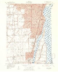
1952 Map of Wyandotte
USGS Topo · Published 1954About this map
The Detroit River serves as the dominant geographical and economic artery for this industrial corridor in the early 1950s, defining the international boundary between Michigan and Ontario. The landscape is a dense network of suburban expansion and heavy industry, stretching from the core of Wyandotte and Lincoln Park south through Riverview to Trenton. Significant infrastructure of the era is visible, including the Oil Refinery near Glee Drain and an Abandoned Quarry north of Trenton. The map captures a moment of rapid educational growth, featuring over twenty-five named schools such as Heintzen Sch No 3 and Roosevelt High Sch. To the west, the transition to less developed lands is marked by Goddard Farms and the Hange Airport, while the residential character of Grosse Ile is established across the Trenton Channel.
Find a feature on this map
103 named features on this map. Tap any name to fly to it.
Don’t see what you’re looking for? This feature index may not catch every label — zoom into the map to look around manually.
Map Details
Editions of this 1952 Wyandotte Map
2 editions found
Other maps of this area

1905 · Wayne
USGS Topo · 1:62,500

1905 · Detroit
USGS Topo · 1:62,500

1906 · Wyandotte
USGS Topo · 1:62,500

1906 · Romulus
USGS Topo · 1:62,500

1912 · Wyandotte
USGS Topo · 1:62,500

1912 · Wayne
USGS Topo · 1:62,500

1918 · Detroit
USGS Topo · 1:62,500

1924 · Detroit
USGS Topo · 1:62,500

1928 · Romulus
USGS Topo · 1:62,500

1929 · Wyandotte
USGS Topo · 1:62,500