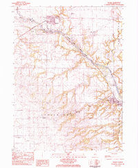
1983 Map of Wyanet
USGS Topo · Published 1984About this map
The Hennepin Canal cuts a distinct path through Bureau County, flanked by a series of historic engineering points including Lock No 18 and Lock No 21. This 1980s landscape is defined by the intersection of water and rail, where the Burlington Northern and Chicago Rock Island and Pacific railroads once served the agricultural hubs of Wyanet and Tiskilwa. The map reveals a high concentration of burial grounds, such as Forest Hill Cem and the County Farm Cem, providing essential data for genealogists tracing family histories in Wyanet and Indiantown townships.
Find a feature on this map
49 named features on this map. Tap any name to fly to it.
Don’t see what you’re looking for? This feature index may not catch every label — zoom into the map to look around manually.
Map Details
Editions of this 1983 Wyanet Map
This is the sole edition of this map. No revisions or reprints were ever made.
Other maps of this area

1893 · Lacon
USGS Topo · 1:62,500

1893 · Hennepin
USGS Topo · 1:62,500

1909 · Hennepin
USGS Topo · 1:62,500

1911 · Hennepin
USGS Topo · 1:62,500

1921 · Buda
USGS Topo · 1:62,500

1923 · Buda
USGS Topo · 1:62,500

1933 · Lacon
USGS Topo · 1:62,500

1933 · Camp Grove
USGS Topo · 1:48,000

1937 · Lacon
USGS Topo · 1:62,500

1945 · Bradford
USGS Topo · 1:62,500